
 David J. Smith taught seventh grade for 26 years at the Shady Hills School, in Cambridge, Mass. He was born and raised in Cambridge and, yes, attended Shady Hills School himself from pre-K through ninth grade. After teaching in Oregon and Hawaii, he applied to teach at Shady Hills and remained there for more than a quarter century. He and his wife now live in Vancouver, Canada, and Smith travels around the world giving workshops based on If the World Were a Village, illustrated by Shelagh Armstrong (Kids Can Press). The same team has also published If America Were a Village (also Kids Can). Both books are part of the CitizenKid series, which has sold more than 700,000 copies worldwide. North American sales of If the World Were a Village (both editions) total more than 277,000 copies. The curriculum Smith developed around his books is called "Mapping the World by Heart," an appropriate name for a subject he's passionate about.
Your book If the World Were a Village began with a question posed by one of your seventh-grade students. Are you still teaching?
I describe my day job as twofold: one is doing in-service training, helping teachers understand how best to encourage children to understand and explore their world--worldmindedness across the curriculum. Each of my books has an essay at the back: How do you talk to children about these very tough, complex issues in a way that helps them think about, deal with and address them.
The second involves my favorite kinds of events in the last two to three years: weeklong stays at interesting schools, where students and teachers have questions for me and I have activities for them.
How did the book get published?
From [that seventh-grader's] first question to the publication of If the World Were a Village took 15 years. On May 19, 1989, my student and I appeared on The Today Show with Brian Gumble. After that Today Show appearance, a Morrow editor came to the school and read 45 pages I had about If the World Were a Village. She offered a five-digit advance, and three-and-a-half years later canceled the contract because they couldn’t figure out the artist for it.
At the end of 1993, I went to Workman with the project. The same thing happened: three-and-a-half years later, they couldn't find an illustrator for it. Then Kids Can bought it. Eleven years later, they've done 18 printings of the first edition, and four of the second edition; 27 countries have bought the rights, and the latest is a Hungarian edition.
 Over the years, what numbers have changed the most?
The most dramatic, since 2002, is the number of telephones. We now are at a point where there are more telephones than people. And of course it's not land lines.
Did you have any material that was not selected for publication in If the World Were a Village?
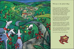
Yes, the dark side [of the global village]. For example, if the scale of land were the same, the 100 people would live in one square mile. In that one square mile, there would be two land mines.
How do you work with schools when you visit?
There's a school in Winnipeg, connected to the Canadian Museum of Human Rights, where I spent a week. Winnipeg is a very cold city, and I visited in December 2012. It can reach -5 degrees Fahrenheit. One of the activities was a water walk. Every child brings a one-gallon container, walks to a source of water, fills the jug, then walks back and uses the water for something.
In Winnipeg, the water was frozen hard. So we walked to a neighborhood recreation center, a little less than a mile each way. The kids were properly dressed, and we walked there and filled the containers--I told them not to fill it too full. The water had partially frozen [by the time they got back to school]. The value of that exercise is putting yourself in the shoes of someone who has to walk a mile each way to get to a source of water--and the real value is writing about it afterwards.
 You've recently returned from a school visit in Switzerland. What was that like?
I spent a week at the International School about 20 minutes outside of Geneva, La Chatagneraie School. On the first day, I met with the teachers of the seven grade levels. The second day was a shorter meeting with the classes of students. On the third day, we did our activity: 650 children, pre-K through sixth grade, and each had the opportunity to put something on a map.
On a concrete top, we created sections on a grid. Each child got one section to draw in chalk. The teachers and I "fixed" the drawing, if necessary. Afterwards, the teachers painted the chalk lines in parking lot paint. On the fourth day, the teachers and parents met to debrief, and the fifth day was a celebration.
The smallest map we ever made was 4½x7½ meters. The largest was in Winnetka, Ill., 45 feetx75 feet.
Tell us about your Website, mapping.com. You post a wealth of statistical information there.
I update that myself every week and create hotlinks for each article. Right now, I have a backlog of 12. If I get tied up, I can easily and quickly put a new one in, take an old one off. I registered the domain name in 1994, and that's how far back the archive goes. At that time, there were teachers that had never looked at an e-mail and never looked at a website. The world has grown geometrically more complicated.
What are you working on now?
The working title is What If? My favorite example: if the history of the earth, starting 4.5 billion years ago, were compressed into a two-hour DVD, the first human being--the first hominid--shambles across your screen in the final second. --Jennifer M. Brown